Opotiki is surrounded by forest and beaches. Experience the area up close and personal by walking or running at one of the tracks around Opotiki.
Many trails are maintained by the Department of Conservation and have detailed information available. Take a walk along the extensive coastline or plan your adventure using some of the online tools, maps and brochures available.
More Information
Marawaiwai Track
Off SH2 onto Warrington Road, then on to Harrison Rd
Opotiki
This is an easy track for the whole family, located 20 minutes from Opotiki township. The track takes about 20-30 minutes to complete and runs alongside a stream through the Kahikitea Forest. There are two bridge crossing across the stream.
There is a grassy picnic spot with table and toilet at the start of the walk.
This is a Department of Conservation track.
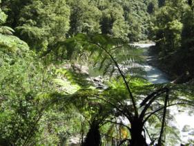
Waioeka Gorge Walking Tracks
Off State Highway 2 between Opotiki & Gisborne
Tauranga Loop Track
Located 26 km south-east of Opotiki on SH2
Easy walking track
Duration: 2 hour loop
There are parking and picnic facilities at the start of this walk. The walk starts next to the road and within 5 minutes reaches the historic Tauranga Bridge. From the bridge you can see stunning views of the Waioeka River and surrounding native bush.
Little Manganuku Track
Starting on the true right of the Manganuku Stream beside the historic Manganuku Stream Bridge
Advanced Walking Track
Duration: 2 hours & 30 minutes one way
Starting from a historic 'Howe truss' bridge this track has excellent waterfall and forest views.
Dogs allowed by permit only. Contact the Department of Conservation for permits.
Manganuku Track
Starting beside the Manganuku Campsite, 47 km from Opotiki, adjacent to SH2 and the Manganuku Bridge
Advanced Walking Track
Duration: 3-4 hours one way
From the Historic Howe Truss Bridge take the gentle benched track that runs beside the true right of the Manganuku Stream.
After about an hour you will get to a directional sign, from here head down to the river to a good swimming hole in the Manganuku Stream. From here you can continue to walk upstream in the river for 2 hours approx and you will arrive at the Manganuku Hut. The river exit to the hut is marked with a large orange track marker. There are some deep stream crossings if river levels are high so check before you leave.
Mangapumarumaru Track
Located 23 km from Opotiki on SH2 in the Waioeka Gorge
Advanced Walking Track
Duration: 3-4 hours one way
This track is for experienced trampers as it is not well maintained and marking in places is inadequate. Sections of the track are strenuous.
For more information on DOC facilities including permits and other information click here to visit the DOC website.
Beach Walks
Pouwhenua to Pipi-bed & return
SH2 west of Opotiki
This easy to moderate fitness level track starts at the Pouwhenua (carved welcome poles) on State Highway 2 just west of Opotiki. Head west along Waiotahi Beach to the river mouth. There are toilets and picnic facilities at the reserve.
Pouwhenua to Waioeka River & Huntress Creek Track
SH2 west of Opotiki
This track is easy and suitable for any fitness level. Starting from the Pouwhenua head east along Waiotahi Beach to the Waioeka River mouth. Return back the same way. Or follow the signs for the Huntress Creek loop track which offers estuary and marshland views, this returns via another track along the sand dunes.